File:site plan of the sanctuary Pillerhöhe.JPG
site_plan_of_the_sanctuary_Pillerhöhe.JPG (608 × 600 pixels, file size: 53 KB, MIME type: image/jpeg)
Description
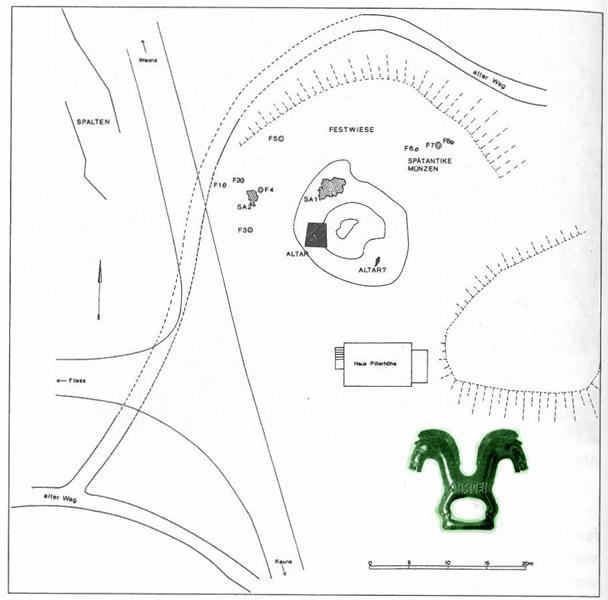
| Description: | site plan of the sanctuary Pillerhöhe given by Tschurtschenthaler and Wein (2002). |
|---|---|
| Motif: | site plan of the sanctuary `Pillerhöhe´ |
| Type: | drawing |
| Format: | upright |
|
| |
| Photographer, Artist: | unknown |
| Copyright Holder: | Athesia Bozen |
| Source: | Tschurtschenthaler & Wein 2002: 638 |
|
| |
| Shown on Pages: | Pillerhöhe, IT-8 potsherd, IT-9 bowl, IT-10 potsherd |
Licensing
The copyright holder only allows this file to be used for non-commercial and/or educational purposes. In case of use, the prior written permission of the copyright holder is required.
Commentary
Site plan of the sanctuary Pillerhöhe given by Tschurtschenthaler & Wein in "Das Heiligtum auf der Pillerhöhe" (2002). The article about the sanctuary Pillerhöhe is part of Liselotte Zemmer-Plank, Wolfgang Sölder (Eds), "Kult der Vorzeit in der Alpen. Opfergaben – Opferplätze – Opferbrauchtum" (2 volumes; Bozen: Athesia 2002), published on pages 635–673. The site plan is indicated on page 638 (fig. 2 "Heiligtum Pillerhöhe. Lageskizze").
The site plan was first published by Tschurtschenthaler & Wein in "Das Heiligtum auf der Pillerhöhe und seine Beziehungen zur Via Claudia Augusta" (in: Elisabeth Walde (Ed.), "Via Claudia. Neue Forschungen", Innsbruck: Institut für Klassische Archäologie der Leopold-Franzens-Universität Innsbruck 1998, 227–259). The site plan is indicated on page 229, fig. 2 ("Heiligtum Pillerhöhe. Lageskizze").
Bibliography
File history
Click on a date/time to view the file as it appeared at that time.
| Date/Time | Thumbnail | Dimensions | User | Comment | |
|---|---|---|---|---|---|
| current | 17:28, 4 May 2015 |  | 608 × 600 (53 KB) | Sindy Kluge (talk | contribs) |
You cannot overwrite this file.
File usage
The following page uses this file:
